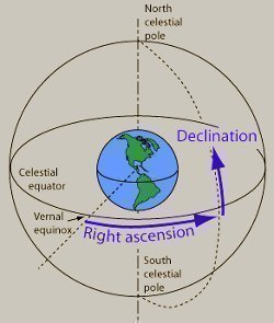
Declination
Declination is a coordinate system that uses Latitude that is then projected on large arbitrary radius measurements around the Earth that rotate on the same axis. Declination’s main purpose is to locate a specific object or point in the sky. It is measured in a value of degrees north and south of the celestial equator. These values are positive if north of the celestial equator, zeroed if equal to the celestial equator, and negative in the south.
For example, the following values are true for declination positions from the celestial equator:
- An object at the Celestial North Pole: +90°
- An object on the Celestial Equator: 0°
- An object at the Celestial South Pole: -90°
Any position between the Celestial North Pole and the Celestial Equator ranges between +89° and +1° on the celestial sphere. Any position between the Celestial South Pole and the Celestial Equator ranges between -89° and -1° on the celestial sphere. When used with the right ascension or hour angle (horizontal position along the Celestial Equator), this declination measurement makes it possible to find a point where an object can be found above a point on the Earth in the Celestial Sphere.

Some objects such as those within the Earth’s solar system have varying declinations due to their position within the solar system, the trajectory angle of the orbits they follow, and the Earth’s current axial tilt.
Navigators use declination as a means of describing the position of the sun or the moon in the sky. If the sun or any other object in the sky is located at a -25° declination, the spot on the Earth directly under the object will be at the -25° latitude mark. The right ascension determines the object’s position of Celestial longitude. With the hour angle, the measurement can be given in units of time or degrees (00:00:00-23:59:59, +0° to +360° W of the Celestial Meridian or -0° to -360° E of the Celestial Meridian). The hour angle can be measured from any of following 3 locations as a starting position:
- The Prime Meridian (Greenwich Hour Angle [GHA])
- The Local Meridian (Local Hour Angle [LHA])
- The First Point of Aries (Sidereal Hour Angle [SHA])
When navigating with a compass and one knows a West declination position, one can determine the true azimuth by subtracting the value from the compass reading. If one knows an East declination value, one can determine the true azimuth by adding the value to the compass reading.
Declination is an important factor in satellite dish/antennae alignment. The declination measurement is what is used to ensure that the dish is set to the correct elevation angle relative to the Earth’s latitude and curvature. Depending on the declination position of one of the several thousand geosynchronous satellites in orbit around the Earth, the angle at which the satellite dish is required to point will vary. Since these satellites are usually moving in a synchronized orbit around the Earth, they appear to be stationary in a single point in the sky to someone observing from the ground.


Comments - No Responses to “Declination”
Sorry but comments are closed at this time.