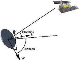
Elevation
Elevation refers to the varying heights of objects on, and around, the Earth. Elevation on Earth is usually used to measure the difference in height of land masses in comparison to Sea Level. Elevation in Earth’s orbit is used to measure the difference in height of satellites in comparison to the Earth’s horizon from any given point. In the latter form, elevation is a critical factor in properly configuring a satellite antenna.
How Elevation Works
Elevation, in terms of satellites, is measured in degrees and depends on the horizon as a reference point. Satellites that are aligned perfectly with the horizon are at 0° elevation while satellites that are aligned directly above an observer, perpendicular to the horizon, are at 90° elevation. The directions, East and West, are also applied to elevation to describe which hemisphere the satellite is in. Therefore, a satellite that rests exactly between the Eastern horizon and above the observer would be described as being at 45° East or having a 45° Eastern elevation.
Applications
Elevation is commonly used to point a satellite antenna towards the appropriate position in the sky. However, elevation is also used for comparing the sizes of land masses, airplane navigation, and artillery. Likewise, elevation can be used for engineering, astronomy, and surveying.


Comments - No Responses to “Elevation”
Sorry but comments are closed at this time.